Thursday, May 01, 2008
Mapping Gotham
As I've said before, I'm a little bit obsessed with maps. And in particular I'm interested in the worldbuilding aspect of mapping fictional locations. Well, something interesting turned up in Kiel Bryant's photostream this morning. It's tagged as "Nolan's Gotham, fully mapped," which I take to mean this is a map of Gotham City as portrayed in Christopher Nolan's Batman Begins.

It appears some hard-working ARG players have gone through and pieced together a full map of the Gotham City Rail, incorporating pieces from various sources.

As the Strange Maps post and others point out, there have been several different maps of Gotham over the years, most of them based on existing cities. What's fascinating to me about these last examples is the way in which Eliot R. Brown's has been gradually refined and codified through the agency of the nameless designers and cartographers working with Christopher Nolan, and how it is gradually becoming, in a sense, a real place. But at the same time the literalization of the social structure of the city suggests that it can still be a symbolic place, as well.
Back in Clockwork Storybook days, we set most all of our stories in the fictional city of San Cibola. Starting from a very rough outline of its geography, with a vague idea of how the various neighborhoods related to one another, over time it became a fairly detailed place. Finn went so far as to draft a gazetteer of all the streets and place names, and Bill roughed out a fairly detailed wall-sized map. Of course, nothing we did even approached the level of verisimilitude that this Gotham map has achieved, but just looking at it now reminds me of that experience, and makes me hungry a little to start mapping a fictional city of my own. (But if I do, I'll be careful to remember James Gurney's mapmaking advice...)
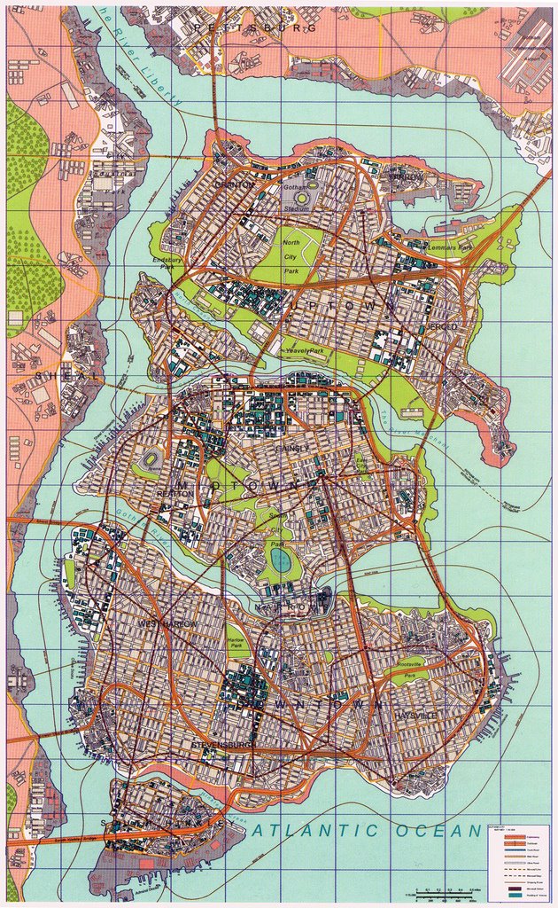
One of the interesting this map is the way it literalizes the social divisions in the city, by physically separating the upper, middle, and lower classes by water. So we've got Uptown, Midtown, and Downtown as the three major "lobes" of the city, separated by waterways.
The only missed opportunity I see here is that the "Narrows," the purview of the underclass, is situated in the middle of the mass, right between Midtown and Downtown, where I think it might be more symbolically appropriate in the position of "South Hinkey" at the bottom of the map.
Here's how David Goyer's script describes it...
The "No Man's Land" map in question is that which appeared in Gotham City Secret Files and Origins #1, and appears to have been done by Eliot R. Brown, the man responsible for codifying Iron Man's tech, writing The Book of Weapons, Hardware, and Paraphernalia appendix to the Official Handbook of The Marvel Universe, doing the cartography for The Marvel Atlas, and much more besides.

A glance at the two maps certainly suggests a familial relation between them. The excellent cartographical blog Strange Maps has done a post on the map, which includes a bit of interesting trivia about the fictional city itself (including mentions of Alan Moore's contributions to the city's history), as well as analysis of the map itself.
This article on FirstShowing.net points to the Gotham City Rail site, part of the viral marketing for The Dark Knight, Nolan's follow-up to Batman Begins. The site includes an interactive map of Gotham's subway lines, and is evidently part of an Alternate Reality Game tied into the marketing campaign.

The only missed opportunity I see here is that the "Narrows," the purview of the underclass, is situated in the middle of the mass, right between Midtown and Downtown, where I think it might be more symbolically appropriate in the position of "South Hinkey" at the bottom of the map.
Here's how David Goyer's script describes it...
A little digging this morning turned up this Wikipedia entry on Gotham City, which has the following unsubstantiated claim: "Director Christopher Nolan commissioned a map of Gotham for his movie Batman Begins that also used the "No Man's Land" map as a basis. The airport was moved to the Northeast, Narrows Island was inserted between Midtown and Downtown, and Wayne Tower was moved to Midtown, about where the "54" marker on the map to the left is located."AN ISLAND IN GOTHAM RIVER: a ramshackle LABYRINTH of crumbling
public housing, makeshift additions GROWING LIKE FUNGUS AROUND
AN INSANE ASYLUM. A walled city. Slick with rain.
The "No Man's Land" map in question is that which appeared in Gotham City Secret Files and Origins #1, and appears to have been done by Eliot R. Brown, the man responsible for codifying Iron Man's tech, writing The Book of Weapons, Hardware, and Paraphernalia appendix to the Official Handbook of The Marvel Universe, doing the cartography for The Marvel Atlas, and much more besides.

A glance at the two maps certainly suggests a familial relation between them. The excellent cartographical blog Strange Maps has done a post on the map, which includes a bit of interesting trivia about the fictional city itself (including mentions of Alan Moore's contributions to the city's history), as well as analysis of the map itself.
This article on FirstShowing.net points to the Gotham City Rail site, part of the viral marketing for The Dark Knight, Nolan's follow-up to Batman Begins. The site includes an interactive map of Gotham's subway lines, and is evidently part of an Alternate Reality Game tied into the marketing campaign.

It appears some hard-working ARG players have gone through and pieced together a full map of the Gotham City Rail, incorporating pieces from various sources.

As the Strange Maps post and others point out, there have been several different maps of Gotham over the years, most of them based on existing cities. What's fascinating to me about these last examples is the way in which Eliot R. Brown's has been gradually refined and codified through the agency of the nameless designers and cartographers working with Christopher Nolan, and how it is gradually becoming, in a sense, a real place. But at the same time the literalization of the social structure of the city suggests that it can still be a symbolic place, as well.
Back in Clockwork Storybook days, we set most all of our stories in the fictional city of San Cibola. Starting from a very rough outline of its geography, with a vague idea of how the various neighborhoods related to one another, over time it became a fairly detailed place. Finn went so far as to draft a gazetteer of all the streets and place names, and Bill roughed out a fairly detailed wall-sized map. Of course, nothing we did even approached the level of verisimilitude that this Gotham map has achieved, but just looking at it now reminds me of that experience, and makes me hungry a little to start mapping a fictional city of my own. (But if I do, I'll be careful to remember James Gurney's mapmaking advice...)
Comments:
<< Home
Likewise, Charles de Lint has fleshed out much of Newford over the years as that fictional city has grown. I know he has a goodly amount of reference notes and a rough physical map sketched out where all the various subsections of the city fit together. But wow, nothing like this.

Yeah, Newford was definitely an influence on San Cibola, at least on my own contributions.
I imagine that something like China Mieville's New Crobuzon has been fairly well mapped out by the author, as well. And of course there are all of those great Discworld maps by Stephen Briggs, which certainly approach this level of complexity, and perhaps surpass it.
I imagine that something like China Mieville's New Crobuzon has been fairly well mapped out by the author, as well. And of course there are all of those great Discworld maps by Stephen Briggs, which certainly approach this level of complexity, and perhaps surpass it.
A Discworld-phile friend of mine recently gave me one of those Discworld maps. Awesome stuff.
Consistent, fictionary cartography is as fun to pour over as the real thing.
Consistent, fictionary cartography is as fun to pour over as the real thing.
Thanks for making my morning with this post, Chris. Have you read Jeremy Black's Maps and History? It's a fascinating book that, among other things, deals with some of the varieties of problems inherent in mapmaking.
The animated series had their Gotham completely mapped out too. They built two huge tomes - one for the production office and one for the animators in Korea - and it opened with a map of the city on a grid, then was followed by one page for each square, showing the major architectural features. So they could say things like "the Joker is held up in a warehouse in A7" or "this chase sees the Batmobile driving from B3 to G6" and ensure that the buildings passed were consistent from show to show.
To my knowledge (I could be wrong) it's never been made commercially available, but I'd love to see it.
To my knowledge (I could be wrong) it's never been made commercially available, but I'd love to see it.
I passed this post on to a buddy of mine, Moshe Feder, consulting editor at TOR, who curates a discussion list on subways & transit, The Third Level (named for the Jack Finney story). He enjoyed your post.
# posted by  :
5/8/08 2:39 PM
:
5/8/08 2:39 PM
:
5/8/08 2:39 PM
Lou, I'll second that wish that the B:TAS atlas you spoke of still exists and could be made available in the bookstores. It would be very interesting to compare their version of Gotham to the various other maps that have aired or seen print over the years.
Post a Comment
<< Home
![]()


