Monday, February 18, 2008
Mapmaking
I'm a little bit obsessed with maps. Have been since I was a kid. I remember tacking up the fold-out maps from National Geographic to the wall, making careful notes in spiral notebooks, marking spots of interest with pushpins, linking them with bits of string. I've always had globes--reproductions of antiques, false-color elevation globes of other planets, you name it.
I use maps a lot in my writing, too. My shelves are stuff with modern atlases, historical atlases, even books on antique atlases and maps, books on mapmaking and mapmakers, etc. And from time to time, I've made my own maps, to help get my head around a particular setting for a story.
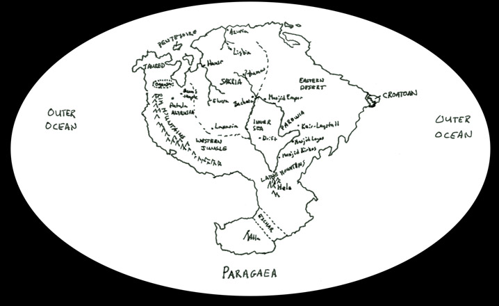
This is the first map I made of Paragaea, when I first started working on Akalina's story, a bunch of years ago. As I've said before (or at least hinted broadly), I used C.R. Scotese's "Pangaea Ultima" as a staring position for what a posthistorical Earth might look like, and went from there.

Not that pretty, but it got the job done, and helped serve as the basis for the version that Ellisa Mitchell did for the Pyr edition.
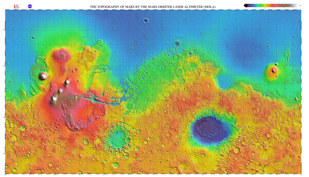
Next is a map I used in writing Iron Jaw and Hummingbird. I've had a few globes and maps of Mars I've used over the years, consulting a table that lists the Celestial Empire names for the various bits of geography, but this was the first time I found it necessary to put together an actual map. Using the MOLA topographical map as my starting position, I just desaturated the image and layered the text labels on top.

Now, obviously, both of these are pretty quick and dirty, for my eyes only and just to get the job done. But from time to time, particularly when working on things like the epic fantasy that keeps percolating, I get the itch to do something a little more elaborate, a little more for public consumption.
And then I see things like this, and I wonder why I should bother. Because whatever I do, D.M. Cornish will have me beat all hollow.
Just check out his map of the "Half-Continent", the setting for his Monster Blood Tattoo series, about which I've raved before.

How awesome is that? The detail maps in the appendices of Foundling, the first book in the series, were a revelation, and one of the main reasons I picked up the book in the first place. But to see how rich and developed they were even as the book was coming together under Cornish's hand is humbling.
I'm now in the process of finishing Three Unbroken, for which I'm making heavy use of a globe of Mars based on the same MOLA map I mentioned above, and using what little free time I can find to noodle with the world of Avani, the setting for my epic fantasy. Having blocked out the broad strokes of the current political climate, the various cultures involved in the story and their general histories, I'm soon to start thinking about the geography beyond the purely notional sketches I've already got in my head. Who knows? Maybe I'll be inspired by Cornish's example to do something really robust this time around.
I use maps a lot in my writing, too. My shelves are stuff with modern atlases, historical atlases, even books on antique atlases and maps, books on mapmaking and mapmakers, etc. And from time to time, I've made my own maps, to help get my head around a particular setting for a story.
This is the first map I made of Paragaea, when I first started working on Akalina's story, a bunch of years ago. As I've said before (or at least hinted broadly), I used C.R. Scotese's "Pangaea Ultima" as a staring position for what a posthistorical Earth might look like, and went from there.
Not that pretty, but it got the job done, and helped serve as the basis for the version that Ellisa Mitchell did for the Pyr edition.
Next is a map I used in writing Iron Jaw and Hummingbird. I've had a few globes and maps of Mars I've used over the years, consulting a table that lists the Celestial Empire names for the various bits of geography, but this was the first time I found it necessary to put together an actual map. Using the MOLA topographical map as my starting position, I just desaturated the image and layered the text labels on top.

Now, obviously, both of these are pretty quick and dirty, for my eyes only and just to get the job done. But from time to time, particularly when working on things like the epic fantasy that keeps percolating, I get the itch to do something a little more elaborate, a little more for public consumption.
And then I see things like this, and I wonder why I should bother. Because whatever I do, D.M. Cornish will have me beat all hollow.
Just check out his map of the "Half-Continent", the setting for his Monster Blood Tattoo series, about which I've raved before.

How awesome is that? The detail maps in the appendices of Foundling, the first book in the series, were a revelation, and one of the main reasons I picked up the book in the first place. But to see how rich and developed they were even as the book was coming together under Cornish's hand is humbling.
I'm now in the process of finishing Three Unbroken, for which I'm making heavy use of a globe of Mars based on the same MOLA map I mentioned above, and using what little free time I can find to noodle with the world of Avani, the setting for my epic fantasy. Having blocked out the broad strokes of the current political climate, the various cultures involved in the story and their general histories, I'm soon to start thinking about the geography beyond the purely notional sketches I've already got in my head. Who knows? Maybe I'll be inspired by Cornish's example to do something really robust this time around.
![]()


